Cincinnati Nature Center Implements Mobile Guide & Map
.jpg)
BACKGROUND
One of the top 10 nature centers in the country, Cincinnati Nature Center comprises more than 1,700 acres of natural and agricultural land. With 20 miles of trails through forests, fields, streams and ponds, this outdoor venue hosts around 250,000 visitors per year. Cincinnati Nature was experiencing challenges with their printed property map. These challenges were intensified further by the coronavirus pandemic. Cincinnati Nature was dedicated to providing resources to their members as well as staying true to their conservation initiatives
PROBLEM
Cincinnati Nature faced four challenges. First, their current property map was inflexible, expensive to print, and not eco-friendly. Any changes to the map required a re-printing. Cincinnati Nature is a conservation organization and a printed, paper map was not consistent with their green initiatives. Next, crowdsourced websites like AllTrails frequently contained incorrect information about Cincinnati Nature’s trails. Despite many attempts, Cincinnati Nature staff were not able to make corrections to these crowdsourced trail maps. Third, when the coronavirus pandemic began in early 2020, printed maps were taken out of kiosks over concerns about the spread of germs. Last, through feedback and surveys, Cincinnati Nature’s members were asking for a digital map.
SOLUTION
The Cincinnati Nature Center team investigated different technology options to address a digital mapping solution. They did not want a downloaded, native app or a platform that required WiFi. Cincinnati Nature was particularly impressed with Engage by Cell’s “blue dot” technology. Ultimately, they chose Engage by Cell’s mobile web app consisting of a mobile guide for content and a GPS Mapper digital map for wayfinding.
• A digital map is consistent with their green initiatives and satisfies member desires.
• Cincinnati Nature now owns their trail map content unaffected by crowdsourced information.
• Anyone on the Cincinnati Nature team can build the mobile web app with an easy drag-drop-interface—no IT department needed.
• Changes and additions can be made at any time, in real-time. • Visitors can access the map through contactless QR codes.
“We talked to other vendors, but we liked this mobile app idea that didn’t require WiFi and only needed cell service. Then, the blue dot technology was the deal maker. That was the number one reason we went with Guide by Cell. We love that we own and control the content. We have access to the software and we can change things. Engage by Cell has been a true partner with us. They’ve been so responsive with our needs. And in the long run, it’s become very cost efficient so we know that we’re using membership dollars wisely.” Laura Schmid, Membership Manager Experience
OUTCOMES
The Cincinnati Nature team observed several positive outcomes as a result of implementing a mobile guide and our GPS Mapper digital map.
COST SAVINGS WITH A DIGITAL MAP
Cincinnati Nature used to spend $6,000 to $7,000 per year in printing costs for paper maps. While printed maps are still available upon request, after the launch of a digital map, printing costs were reduced to $2,000 per year.
EASY WAYFINDING WITH LESS SIGNAGE
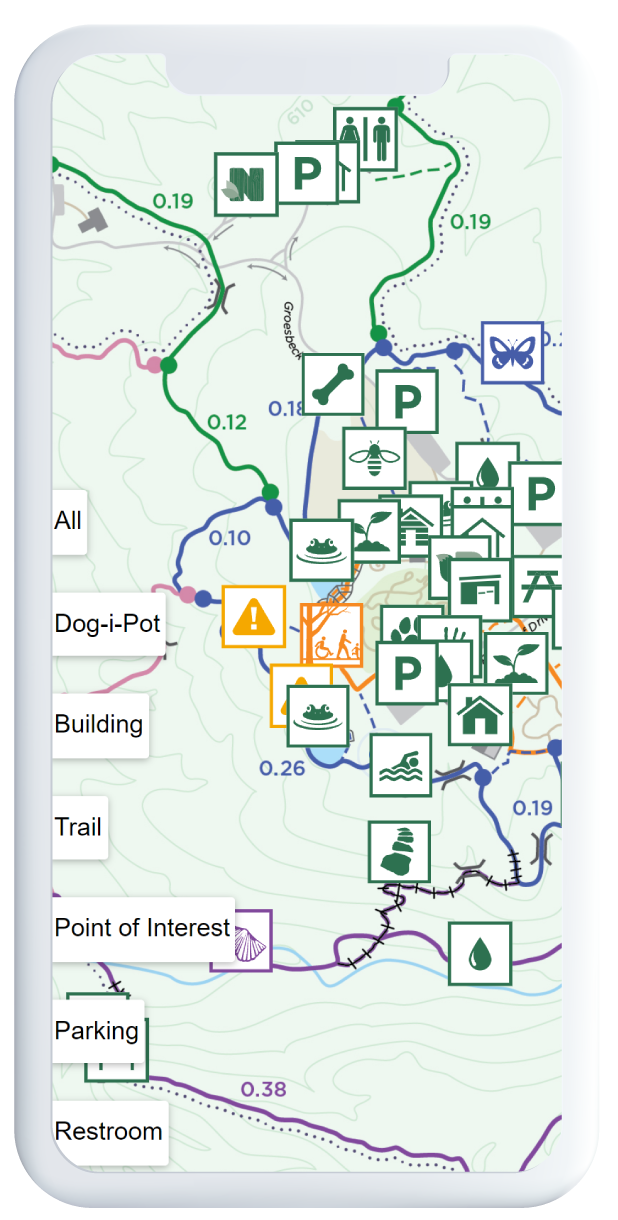
GPS Mapper digital map makes wayfinding easy for visitors and allows Cincinnati Nature to highlight points of interest through interactive pins. The digital map identifies historical landmarks, restrooms and parking. There are not a lot of physical signs on the properties because Cincinnati Nature did not want to impede the natural beauty of the landscape.
“In the first two months since we launched, we’ve had 4,000 unique users and 40,000 page views. This well exceeded our expectations. We were really excited that so many people were using it. The most visited pages are the maps and trail info. What’s really nice is you can track the data on which pages people are using most often.” Maria Jenkins, Digital Learning Manager
TRAIL UPDATES IN REAL TIME
The Cincinnati Nature team can now update the map and identify trail closures in real time. For example, Cincinnati Nature had a large tree go down which released a swarm of yellow jackets. As a result, Cincinnati Nature closed off the trail. The team put warning signs on the digital map so that people would be immediately informed.
THE ENGAGE BY CELL EFFECT
1 Mobile web app housing visitor engagement contentand a digital map
4,000 Users accessing the mobile content and digital map
40,000 total page views
$5,000 savings in printing costs Time
Period: June 2021 – September 2021
Thanks to Engage by Cell’s mobile technology and the Cincinnati Nature team, Cincinnati Nature now has a cost-effective, visitor engagement and wayfinding tool that meets green initiatives and is easy to update. To date, Cincinnati Nature’s mobile guide contains the digital trail map, trail tours and information, scavenger hunts, opportunities to share photos, event information, volunteer opportunities, donation links, and feedback forms.
%20(1).png)


